

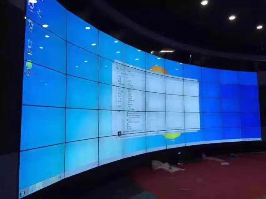
5×10 LCD Video Wall for Regional Traffic Command Centers
A fifty-panel operations wall for regional traffic maps, incidents, cameras and response coordination.
Description
See an Entire Regional Road Network at Operational Scale
A 5×10 LCD video wall for regional traffic command centers provides a fifty-panel surface for road maps, junction cameras, incident queues, weather information and response resources. The wide format allows operators to retain a regional overview while enlarging an affected corridor or interchange for detailed coordination.
The display should be arranged around traffic decisions. Routine layouts can show network speed, congestion, planned works and public transport links. When an incident occurs, the wall can expand cameras, lane status, diversion routes and emergency communications without removing the wider network context.
Move from Detection to Diversion with Saved Layouts
Traffic teams normally detect a change, verify it with cameras or sensors, assess the impact, coordinate responders and publish travel information. Presets for each stage reduce manual window arrangement. Stable source positions help different shifts understand the wall immediately when responsibility changes.
Incident numbers, road names and timestamps should match across maps, camera systems, operator logs and public information platforms. A clear data-age indicator prevents delayed sensor data or a frozen camera from being treated as current conditions.
Keep Maps, Camera Labels and Route Details Readable
A large panel grid contains many bezel lines. Route numbers, junction names, lane diagrams and small text should stay within safe zones. Content templates should define regional overview, corridor focus, incident response and executive briefing layouts.
The 5×10 LCD video wall for regional traffic command centers should be tested from every console row using real maps, dark camera feeds, weather layers and moving traffic data. Alarm colors need sufficient contrast without making routine information visually exhausting during long shifts.
Integrate Cameras, Sensors and Public Information Systems
Document video management, traffic analytics, mapping, variable-message-sign control, weather, communications and conferencing sources. Confirm output resolution, window capacity, network boundaries and user permissions before selecting the processor and control platform.
Public messages should follow an approval process separate from internal monitoring. Operators may verify an incident on the wall, but publication to roadside signs or traveler channels should use the organization’s established authorization. This protects public information while keeping the control room responsive.
Segment Infrastructure for Maintenance and Recovery
The survey should cover supporting structure, power zones, signal distribution, rack capacity, ventilation and service access. Labelled panel positions, cables and processing nodes allow one section to be maintained without disturbing the complete wall.
Continuity planning should state which maps and incident lists must remain available, how quickly recovery is required and who performs the changeover. UPS and redundant components should follow these objectives. An approved fallback source is more useful than a frozen image with no visible status.
Commission with a Realistic Corridor Incident
Acceptance should simulate congestion detection, camera verification, lane closure, emergency coordination, diversion planning, public message approval and return to normal operation. Confirm preset switching, synchronization, readability, permissions and source recovery.
For quotation, provide room dimensions, console positions, road-network coverage, camera and system counts, operating hours, security requirements and recovery targets. These details define the display, processing, mounting, cabling, commissioning and training scope.
Frequently Asked Questions
Can one corridor fill the entire wall?
Yes. A saved layout can enlarge one map, camera group or incident view across the complete canvas.
Can cameras and traffic maps be displayed together?
Yes, after source resolutions, window capacity and control permissions are confirmed.
Can different shifts use the same presets?
Yes. Named, documented presets help maintain consistent operating practice between shifts.
What should be tested before handover?
Use a realistic traffic incident to test verification, layouts, public-message workflow, source failure and recovery.
Inquiry
You must be logged in to post a review.
Related products
-

3×1 Vertical LCD Video Wall for Shopping Malls
Fit a Tall Digital Surface…
-
3×5 Floor Standing LCD Video Wall for Energy Control Rooms
Why a Floor Cabinet Fits…
-
4×5 LCD Video Wall for Shopping Center Event Spaces
Build a Flexible Twenty-Panel Canvas…
-
4×4 LCD Video Wall for Network Operations Centers
A sixteen-panel monitoring canvas for…
Reviews
There are no reviews yet.